

1. Introduction
AI4FLOOD responds to the critical and urgent challenge of improving societal protection against fluvial and pluvial floods, which represent one of the most frequent and economically devastating natural hazards worldwide. The frequency, intensity, and socioeconomic impact of these extreme weather events are rapidly increasing due to the global effects of Climate Change. Traditional flood management strategies often rely on structurally intrusive solutions that can cause severe negative impacts on fluvial ecosystems. In contrast, flood Early Warning Systems (EWS) offer an environmentally friendly, non-aggressive, and highly sustainable methodology to mitigate risks and enhance civil protection.
The current operational paradigm for most EWS relies on a sequential modeling chain consisting of meteorological, hydrological, and hydraulic computational modules. However, the predictive capabilities, compounding errors, and mathematical uncertainties within this cascading chain are still poorly understood, which can result in inaccurate alerts. AI4FLOOD addresses these scientific and technical limitations by investigating the smart, synchronized integration of physically-based numerical models with advanced Artificial Intelligence (AI) algorithms. By leveraging error-correction machine learning, deep learning ensemble frameworks, and high-efficiency surrogate modeling, the project aims to dramatically enhance the precision, Lead time, and reliability of short-term flood forecasting.
2. Funding
 Agencia Estatal de Investigación (Ministerio de Ciencia, Innovación y Universidades, Gobierno de España), co-funded by the European Union, under the call «Proyectos de Generación de Conocimiento 2023».
3. Main and Specific Goals
The primary objective of AI4FLOOD is the development, testing, and operational deployment of novel, highly efficient methodologies to improve short-term forecasts (ranging from a few hours up to 72 hours) of both fluvial and pluvial flood risks within real-time Early Warning Systems. This is achieved by combining the fundamental physical consistency of numerical models with the computational speed and pattern-recognition capabilities of AI algorithms, thereby minimizing economic losses and ensuring infrastructure and human safety.
Specific objectives are organized according to the core technical Work Packages of the AI4FLOOD project:
- WP1. Rigorously evaluate and audit the current operational performance, systematic errors, and predictive weaknesses of each individual module within an existing physically-based EWS over a continuous four-year operational window.
- WP2. Maximize the accuracy of short-term, high-resolution rainfall forecasts generated by numerical weather prediction models through the application of error-correction Machine Learning (ML) techniques and historical radar-gauge data merging.
- WP3. Enhance the robustness and precision of river streamflow and hydrograph forecasts by designing multi-model ensemble architectures driven by Deep Learning (DL).
- WP4. Replicate the physical spatial accuracy of highly detailed 2D hydraulic models while reducing computational times by several orders of magnitude through the training of advanced AI-based deep convolutional surrogate models.
- WP5. Quantify and exploit the scientific added value of high-resolution river mouth discharge forecasts as dynamic boundary conditions to optimize operational coastal hydrodynamics, salinity tracking, and oceanographic predictive systems.
4. Methodology
WP1. PERFORMANCE OF PHYSICALLY-BASED FORECAST MODELS
Overall description: 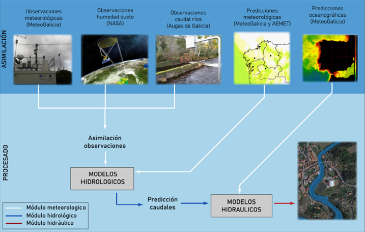
WP1 establishes the empirical baseline of the project by conducting a comprehensive, multi-variable performance audit of the operational Early Warning System named MERLIN. MERLIN was previously developed by the research team for the regional water authority (Augas de Galicia) and currently provides automated daily predictions across 24 river catchments and 14 Areas of Potential Significant Flood Risk (APSFR). By systematically comparing years of archived numerical model forecasts against empirical field observations, WP1 aims to precisely isolate, quantify, and categorize systematic errors. This diagnosis is crucial since mathematical errors propagate and compound down the forecasting chain, where precipitation inaccuracies directly distort hydrological hydrographs, which subsequently invalidate hydraulic water depth alerts.
Activities:
-
- A1.1 Evaluation of Weather Research and Forecasting (WRF) Rainfall Forecasts: Comparing short-term WRF numerical weather models against 4-km resolution historical conditional-merging raster maps derived from 153 real-time ground rain gauges and regional weather radars.
- A1.2 Evaluation of HEC-HMS Hydrograph Forecasts: Statistical auditing of simulated streamflows against physical measurements collected at 29 distinct, telemetered river gauge control points, isolating internal hydrological modeling defects from inherited meteorological forcing errors.
- A1.3 Evaluation of Iber Water Depth Forecasts: Qualitative and quantitative validation of 2D hydraulic inundation models by cross-referencing maximum flood extensions and water depths with empirical social media feeds, historical press logs, and municipal emergency records to calibrate crucial alarm indices (False Alarm Ratio, Hit Ratio, CSI).
Contribution of the University of Coruña:
The University of Coruña acts as the core scientific lead for WP1. Leveraging its extensive data architecture and deep knowledge of the MERLIN engine, UDC researchers will perform the statistical extraction, data alignment, and computing routines required to compare historical predictions with empirical gauge records. The university will lead the development of specialized performance indices tailored to high-discharge flood peaks, providing the critical diagnostic data required to feed the subsequent AI work packages.
WP2. IMPROVING SHORT-TERM RAINFALL FORECASTS WITH ERROR CORRECTION
Overall description:
WP2 focuses on correcting the errors that frequently occur in numerical weather prediction models, which dictate the flash-flood responses of catchments. By treating this as an Output Domain Transformation challenge, WP2 uses data-driven algorithms to learn the structural behavior of meteorological simulation errors and dynamically correct real-time precipitation fields before they are forwarded to hydrological models.
Activities:
-
- A2.1 Diagnosis of the WRF Rainfall Forecast Error: Gathering, structuring, and labeling extensive datasets to classify weather prediction discrepancies into distinct error archetypes (e.g., underestimation, overestimation, timing lags) using machine learning classification models trained on historical atmospheric patterns.
- A2.2 Correction of the WRF Rainfall Forecast Error: Building, training, and validating specialized Deep Learning architectures designed to execute complex data transformations, aligning real-time WRF numerical grids with observed regional precipitation patterns.
Contribution of the University of Coruña:
Under the direct scientific leadership of Dr. Luis Cea Gómez, the University of Coruña will design the machine learning diagnostic and correction pipeline. UDC will engineer the data-ingestion scripts to process raw radar and gauge fields from Meteogalicia, construct the custom neural network loss functions designed to prioritize intense convective storm events, and integrate the finalized error-correction code into the operational forecasting loop.
WP3. IMPROVING PHYSICALLY-BASED HYDROLOGICAL FORECASTS WITH ENSEMBLE MODELLING
Overall description:
WP3 implements an advanced multi-model ensemble framework to dramatically improve river streamflow predictions. Recognizing that single, deterministic hydrological models fail to capture the full spectrum of natural catchment variability, this package combines the physical rigor of semi-distributed models with the swift data-processing capabilities of deep neural networks and simplified lumped models.
Activities:
-
- A3.1 Streamflow Forecasting with DL Techniques: Implementing and tuning Recurrent Neural Networks, specifically Long Short-Term Memory (LSTM) and Gated Recurrent Units (GRU), combined with Convolutional Neural Networks (CNN) to predict discharge, utilizing Monte Carlo Dropout (MCD) methods for explicit uncertainty quantification.
- A3.2 Streamflow Forecasting with Lumped Models: Calibrating and executing the high-speed regional lumped hydrological model known as MHIA across all target basins using historical discharge series to provide a computationally efficient parallel prediction stream.
- A3.3 Multi-Model Ensemble Streamflow Integration: Evaluating and implementing advanced blending techniques—ranging from weighted model averaging and multiple linear regressions to Artificial Neural Networks (ANNs)—to synthesize outputs from HEC-HMS, MHIA, and DL models into a single optimized hydrograph.
- A3.4 Forecasting Human-Regulated Reservoir Release: Overcoming the rigidity of standard rule-based reservoir routing by training hybrid machine learning algorithms (LSTM/CNN) on historical water storage levels, real-time inflow, and manager decision logs across 14 major regional dams.
Contribution of the University of Coruña:
Led by Dr. Jerónimo Puertas Agudo, the University of Coruña will deploy its proprietary MHIA model across the complete catchment network. UDC researchers will lead the mathematical formulation of the multi-model blending layer and the creation of the reservoir-release prediction models. The university will also oversee the scaling of LSTM and GRU configurations, previously restricted to small pilot areas, across the entirety of the MERLIN hydrographic basin network.
WP4. IMPROVING WATER DEPTH FORECASTS WITH SURROGATE MODELLING
Overall description:
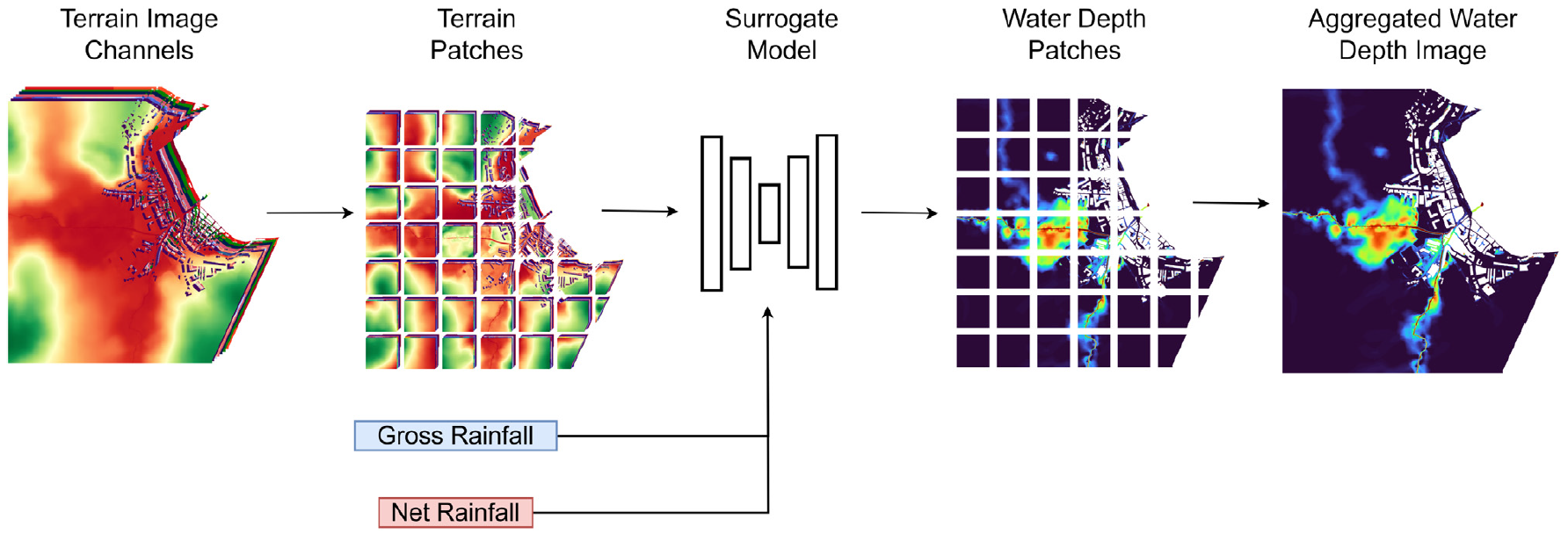
While high-performance computing utilizing Graphics Processing Units (GPUs) has accelerated 2D shallow water equation models, the processing times required for high-resolution inundation grids remain a bottleneck for real-time EWS scenario planning and uncertainty analysis. WP4 breaks this barrier by using deep learning image segmentation architectures to construct digital «surrogate models». These surrogates act as high-speed emulators that learn the complex, non-linear hydraulic behavior of a specific urban area, allowing them to instantly generate 2D water depth maps with the accuracy of a full hydraulic model but in a fraction of the time.
Activities:
-
- A4.1 Implementation of Iber+ High-Resolution Models: Building ultra-detailed 1-meter spatial resolution 2D hydraulic models using the GPU-accelerated software Iber+ and Iber-SWMM for two contrasting pilot zones: Ponte Caldelas (subject to fluvial flooding) and Sada (subject to compound fluvial, pluvial, and tidal flooding).
- A4.2 Deep Learning Surrogate Model Training: Generating hundreds of pre-calculated hydraulic scenarios to train state-of-the-art U-Net and U-ResNet deep learning architectures, incorporating dense topographical indicators (slopes, gradients, elevations) to emulate spatial water depth distributions instantaneously.
- A4.3 Camera-Based Field Infrastructure Setup: Procuring and installing a field network of specialized video-surveillance cameras equipped with infrared night-vision and telemetered GSM data-loggers to continuously monitor physical measuring rulers at key urban river locations in Sada.
- A4.4 Computer Vision Image Processing: Developing and training real-time AI computer vision object-detection algorithms to automatically detect water surface lines from camera frames, providing continuous water level verification data.
Contribution of the University of Coruña:
The University of Coruña will lead this work package by exploiting its position as one of the primary developers of the Iber simulation suite. UDC will build the dual 1D-2D urban drainage Iber-SWMM configurations, execute the heavy GPU computing routines required to build the training datasets, and program the U-Net convolutional frameworks. Furthermore, UDC field technicians will manage the physical installation, municipal permitting, and computer-vision coding for the real-time monitoring cameras.
WP5. EXPLOITING STREAMFLOW FORECASTS IN COASTAL MODELS
Overall description:
WP5 bridges the gap between terrestrial hydrology and marine oceanography by routing the high-resolution discharge hydrographs calculated by the upgraded EWS directly into operational coastal models. In critical estuarine systems, riverine freshwater inputs strongly dictate coastal current dynamics, thermal stratification, and salinity gradients. By replacing crude daily averaged river flow estimates with dynamic, high-frequency physical forecasts, this work package improves oceanographic predictive systems, which are vital for protecting local maritime economies and tracking ecological shocks.
Activities:
-
- A5.1 Extension of Hydrological Frameworks to River Mouths: Coding and structural database modification of the core hydrological modules to calculate and log continuous discharge predictions exactly at coastal estuary entry points.
- A5.2 Impact Analysis on Estuarine Hydrodynamics: Executing sensitivity and impact analyses within a high-resolution 3D hydrodynamic model of the Ría de Vigo estuary, assessing temperature and salinity field distortions during extreme flood runoffs.
- A5.3 Operational Oceanographic Pipeline Integration: Designing and implementing automated data pipelines to feed real-time, high-resolution discharge datasets directly into the daily operational marine models run by state agencies.
Contribution of the University of Coruña:
UDC will lead the computational extension of the river basin models down to the Atlantic marine boundaries. UDC personnel will analyze the resulting estuarine salinity profiles and cross-reference numerical results with experimental marine data from the RADIALES monitoring network.
5. Partners
The core institutional partners, supporting public entities, and research infrastructures involved in the co-development and execution of the AI4FLOOD framework are as follows:
-
- Universidade da Coruña (UDC): Represented by the Water and Environmental Engineering Group (GEAMA), acting as the host institution and scientific leader of the project.
- Augas de Galicia: The Regional Water Administration of Northwest Spain, providing extensive river gauge monitoring data, flood camera access, and acting as the primary end-user for technology transfer.
- Meteogalicia: The Regional Meteorological Agency, providing open-access high-resolution WRF numerical weather forecasts, radar fields, and operating the target coastal hydrodynamic models.
- Centro de Supercomputación de Galicia (CESGA): Providing the high-performance supercomputing clusters, advanced GPU nodes, and secure relational database architectures required to host the operational forecasting engines.
6. Dissemination
- Scientific and technical publications directly derived from the project’s results
Montalvo, C., Tamagnone, P., Sañudo, E., Cea, L., Puertas, J., Schumann, G. (2025) Sewer Network Data Completeness: Implications for Urban Pluvial Flood Modelling. Journal of Flood Risk Management
Farfán-Durán, J. F., Montalvo, C., Cea, L., Leitão, J. P. (2025) Integrating net rainfall calculation in deep learning-based surrogate modeling frameworks for 2D flood prediction. Journal of Hydrology
Cea, L.; Sañudo, E.; Montalvo, C.; Farfán, J.; Puertas, J.; Tamagnone, P. (2025) Recent advances and future challenges in urban pluvial flood modelling Urban Water Journal
- Attendance at conferences, seminars, or workshops related to the Project
INTERLABS Xornada divulgación científica técnica torno ás áreas investigación CITEEC (2026). Mejora de las previsiones de inundación generadas con modelos de base física mediante técnicas de inteligencia artificial (oral). Patricio, M.
ZHydro Seminar (2025). Antecedent Moisture Matters: Integrating Net Rainfall into Deep Learning Surrogates for Urban Flood Prediction (póster). Farfán-Durán, J. F., Montalvo, C., Cea, L., Fenicia, F., & Leitão, J. P.
VIII Jornadas de Ingeniería del Agua (2025). ¿Y la humedad antecedente? Integrando la lluvia neta en modelos subrogados basados en deep learning para predicción de inundaciones urbanas (oral). Farfán-Durán, J. F., Montalvo, C., Cea, L., & Leitão, J. P.
VIII Jornadas de Ingeniería del Agua (2025). Análisis del rendimiento del sistema de alerta temprana MERLIN: evaluación de sus modelos predictivos de base física. Sañudo, E., Montalvo, C., Farfán, J., Araneda-Cabrera, R., Montenegro, M., Puertas, J., Fraga, I. & Cea, L.
VIII Jornadas de Ingeniería del Agua (2025). Estrategias para la modelización de inundaciones pluviales urbanas en escenarios de escasez de datos sobre la red de drenaje (oral). Montalvo, C., Sañudo, E., Cea, L., Puertas, J
VIII Jornadas de Ingeniería del Agua (2025). Modelización de cubiertas en modelos de drenaje urbano a gran escala bajo escenarios de escasez de datos (póster). Montalvo, C., Sañudo, E., Cea, L., Puertas, J.
SimHydro (2025). Roof representation in large-scale urban drainage models under incomplete data conditions (oral). Montalvo, C., Sañudo, E., Cea, L., Chen, A. S., Puertas, J., Evans, B.
- Collaborations with other research groups directly related to the Project
Esteban Sañudo, a member of the Working Group, has been conducting a postdoctoral fellowship at the Università della Calabria in the Dipartimento di Ingegneria dell’Ambiente (DIAM) since October 1, 2025. The fellowship, which focuses on the development of an Early Warning System for rain-induced flooding, includes an initial analysis of the effect of temporal and spatial variability in forecast products and their potential for improvement. The knowledge generated in this area provides significant added value to the project, particularly in Work Package 1 (O1).
Juan F. Farfán-Durán, a member of the Working Group, is a postdoctoral researcher in the Systems Analysis, Integrated Assessment and Modeling (SIAM) department at Eawag, a Swiss research institute for water science and technology affiliated with ETH Zurich. His research focuses on the development of hybrid hydrological and hydraulic models based on artificial intelligence, including deep learning and surrogate modeling to improve hydrometeorological and flood forecasts, contributing to Objectives O1, O2, and O3 of the project. He is also involved in supervising a doctoral thesis related to the development of deep learning-based hydrological models within the project.
7. People
Luis Cea Gómez | luis.cea@udc.es
Jerónimo Puertas Agudo | jeronimo.puertas@udc.es
Esteban Sañudo Costoya | e.sanudo@udc.es
Ignacio Fraga | ignacio.fraga@udc.es
Luis Pena Mosquera | luis.pena@udc.es
Juan Fernando Farfán Durán | j.farfan@udc.es
Carlos Israel Montalvo Montenegro | carlos.montalvo@udc.es
Martín Patricio Montenegro Ambrosi | martin.montenegro@udc.es
André Conde Vázquez | andre.conde@udc.es