

Our research activity in the context of flood risk assessment and management includes the analysis and development of:
- New methodologies to improve the assessment of fluvial and pluvial flood hazard
- River flood early warning systems
- High-resolution hydrological and hydraulic numerical models for the evaluation of river flow and flood hazard
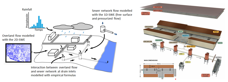
- Dual 1D-2D urban drainage models
- Combining physically-based numerical models with artificial intelligence techniques
- Impact of climate change on floods
- Flood hazard in data scarce regions
- Communication of flood risk concepts
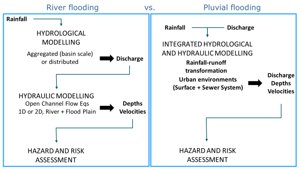
New methodologies to improve the assessment of fluvial and pluvial flood hazard
Fluvial and pluvial flood hazard assessment and modelling is one of our main research interests (Cea et al., 2025). Our recent research has focused in: accounting for the sewer network in the absence of comprehensive field data (Montalvo et al., 2024), identification of pluvial and fluvial flood hazard (Perrini et al., 2025), incorporating antecedent moisture conditions and intra-event variability of rainfall on flood frequency analysis (Cea and Fraga, 2018), evaluation of compund flood hazard in coastal river reaches (Sopelana et al., 2018; Bermúdez et al., 2019), quantifying the effect of rainfall and boundary conditions uncertainty on the performance of flood inundation models (Fraga et al., 2019; Bermúdez et al., 2017).
Within the project ‘SATURNO: Early warning against pluvial flooding in urban areas’ (PID2020-118368RB-I00) we contributed to the improvement of pluvial flood risk management plans by establishing a robust methodology for the development and implementation of operational EWS for pluvial flood risk in urban areas. The main objectives of this project were: 1) to improve the capabilities and performance of current urban drainage models used for the definition of pluvial flood hazard and risk maps; 2) to establish a methodology and recommendations for the implementation of pluvial flood models in an operational EWS; 3) to implement efficient ways of communication and dissemination of flood risk warnings to the population and civil protection agencies.
We are also involved in the project ‘MyFlood: Sistema multiescala híbrido para la predicción en el corto plazo y las proyecciones de cambio climático de la inundación debida a fenómenos compuestos ’, in collaboration with other Spanish research institutions, in order to advance in the development of methodologies for the estimation of compound flooding at different spatial and temporal scales.
Flood early warning systems
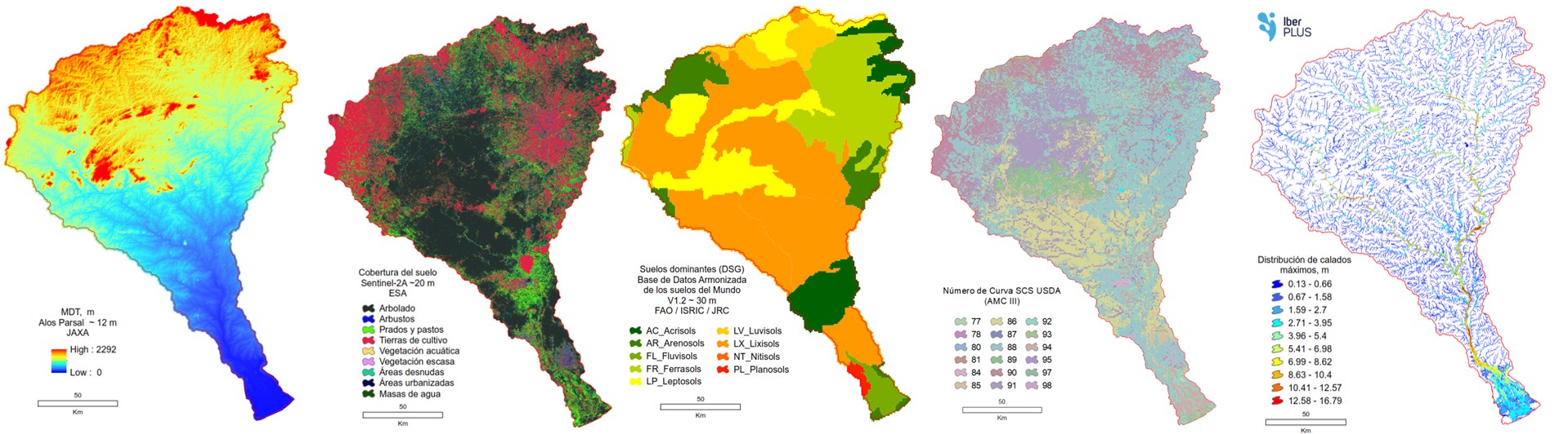
We are working in collaboration with Augas de Galicia (a regional water administration of the Northwest of Spain) in the development of a new local flood early warning system (MERLIN) which delivers discharges and flood extent forecasts on a daily basis from meteorological predictions. (Fraga et al. 2020 and 2021). MERLIN incorporates remote observations to characterize the initial soil infiltration capacity prior to the discharge forecast. Discharges are forecasted using numerical weather predictions that feed a semi-distributed model of flood prone catchments. To forecast the flood extension, MERLIN uses the 2D inundation model Iber+ (García-Feal et al. 2018), which is a GPU-parallelized version of the model Iber (Bladé et al. 2014).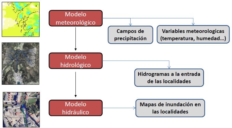
Currently, within the project ‘AI4FLOOD: Enhancing Physically-based Flood Forecasting with Artificial Intelligence’ (PID2023-148074OB-I00) we are working on the efficient combination of physically-based numerical models with Artificial Intelligence (AI) techniques to improve the daily flood risk forecasts delivered by the operational Early Warning System MERLIN in NW Spain.
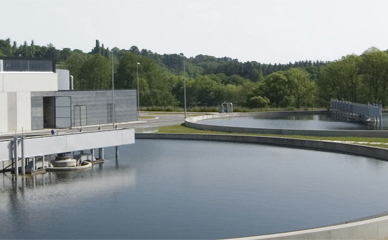
High-resolution hydrological and hydraulic numerical models for the evaluation of river flow and flood hazard
We have worked intensively in the development of hydrological and hydraulic models for more that 15 years. In this field we collaborate with the Flumen institute and the International Centre for Numerical Methods in Engineering (CIMNE) in development of the software Iber (www.iberaula.com).
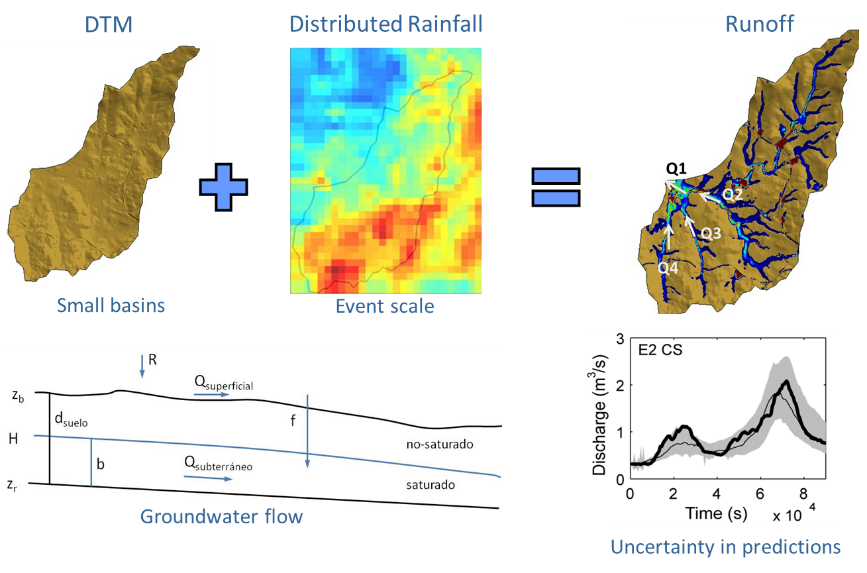
Our work is mainly focused in the development of new mathematical implementations and numerical methods for the 2D shallow water equations. Our recent work in the project VAMONOS was focused on the hdyraulic implementation of bridges and weirs in 2D shallow water models (Cea et al. 2022; García-Alén et al. 2021) and on the modelling of mixed free-surface-pressurized flows with the 2D shallow water equations (Cea and Lopez-Nuñez, 2021). Another important contribution is the development of simple and efficient unstructured finite volume schemes for solving the shallow water equations in overland flow applications (Cea and Bladé, 2015), and their application to high-resolution hydrological modelling (Uber et al. 2021; Tamagnonge et al., 2020; Cea et al. 2016; García-Alén et al. 2022; García-Alén et al., 2023), as well as the development of tools for the calibration of hydrological models based on the shallow water equations (García-Alén et al., 2024). We are also interested in coupling already existing hydrological and hydraulic models for a more realistic and integrated simulation of hydrological-hydraulic processes (Perrini et al., 2024).
We also work in the development of efficent numerical solvers, using High Performance Computing techniques that take advantage of the parallelization functionalities of central processing units (CPUs) and graphics processing units (GPUs). A GPU-parallelized implementation of the 2D shallow water equations (García-Feal et al., 2018), including a water quality module (Cea et al., 2016 ; García-Feal et al., 2020) and a soil erosion module (Cea et al., 2024), is freely available with the software Iber (www.iberaula.com).
Dual 1D-2D urban drainage models
We started working in the development of dual urban drainage models with the project MODUS (Numerical modelling of Sustainable Urban Drainage Systems), supported by the Galicia Regional Government. The outcome was a dual 1D-2D drainage model, developed within the PhD Thesis of Ignacio Fraga, which was validated under controlled laboratory conditions (Fraga et al., 2017). We are also interested in the calibration, validation, sensitivity analysis and quantification of output uncertainty in 1D-2D dual urban drainage models (Fraga et al., 2016; Naves et al., 2020; Addison-Atkinson et al., 2024).
Currently we work on the development of a 1D-2D dual drainage model that couples the models Iber and SWMM (Sañudo et al. 2020; Sañudo et al., 2025). The model was validated within the PhD Thesis of Esteban Sañudo (Sañudo, 2024), using the urban rainfall facility available in the CITEEC. The experimental campaign carried out at the facility includes tests to evaluate the rainfall-runoff transformation on roofs (Sañudo et al., 2022) and streets considering the effect of the sewer network (Sañudo et al., 2024). The experimental data obtained are freely available at ZENODO. Sustainable Urban Drainage Systems (SUDS) are also being incorporated in the model. Within the framework of the DRAIN project (DRAIN. Digital RAIN, un modelo integral de drenaje urbano/DRAIN Digital RAIN, an integrated urban drainage model. Ref [CPP2021-008756]. Componente 17, Inversión 3, BDNS: 602450, financiado por MCIN/AEI/10.13039/501100011033 y por la Unión Europea-NextGenerationEU/PRTR.), we started the development of a 1D-2D modelling tool integrated in a GIS environment for the analysis of all urban drainage processes.
Combining physically-based numerical models with artificial intelligence techniques
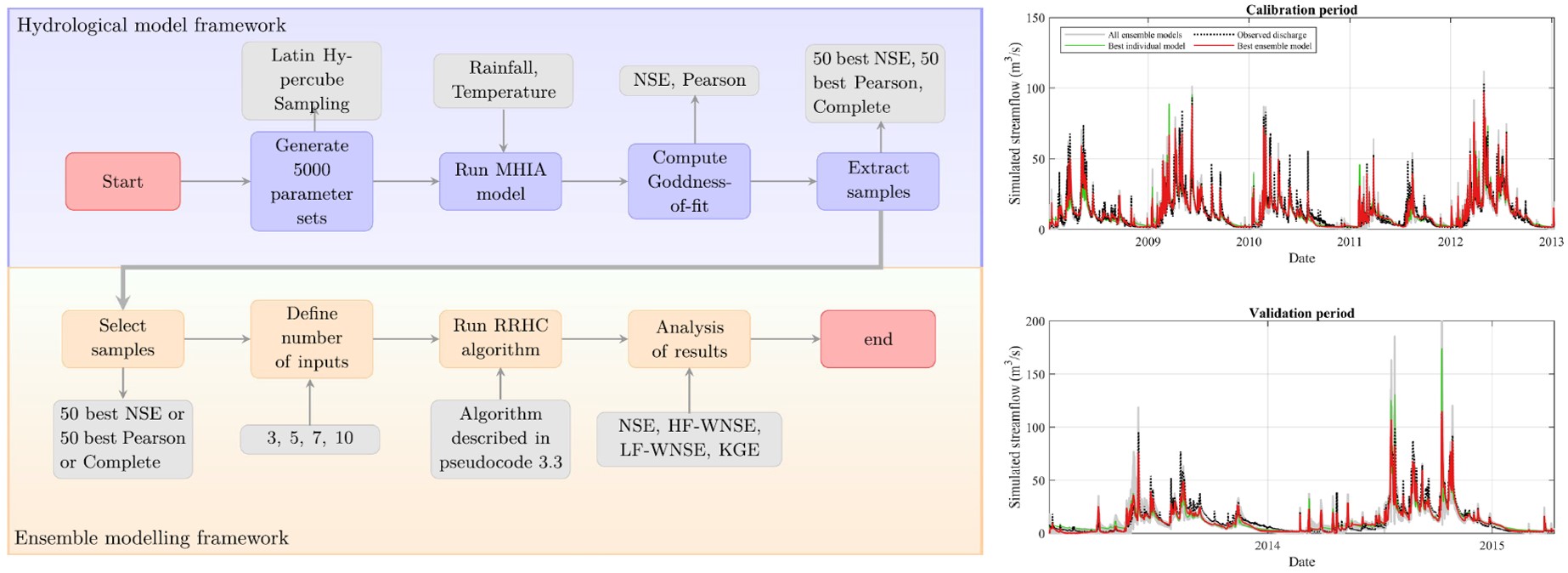
We are interested in the application of machine learning techniques in order to improve the predictive skills and efficiency of hydrological and hydraulic models. We have worked on the implementation of rapid flood inundation models for hazard mapping at the reach scale, using regression techniques based on LS-SVM as a computationally efficient surrogate of 2D shallow water equations models (Bermúdez et al., 2019). In the PhD Thesis of Juan Farfán we worked on coupling machine learning techniques with physically-based models for several purposes as: the calibration of different kind of hydrological models, including simple lumped models (Farfán and Cea, 2023; Farfán and Cea, 2021) and physically-based fully distributed models (Farfán-Durán et al., 2024), or the improvement of the computational efficiency using AI-based surrogates of physically-based models.
Currently, within the project “AI4FLOOD: Enhancing Physically-based Flood Forecasting with Artificial Intelligence” (PID2023-148074OB-I00), supported by the Spanish Ministry of Science, Innovation and Universities (MICIU/AEI/10.13039/501100011033), we continue to work on the combination of physically-based models with Artificial Intelligence (AI) techniques applied to operational flood Early Warning Systems.
Impact of climate change on floods
High precipitation events are expected to increase in number and magnitude in the following decades due to climate change. At the same time, global mean sea level has risen about 20 centimeters since 1900, and is expected to continue increasing even faster in the following decades. We are interested in developing methodologies to quantify both effects in the characterization of flood hazard in rivers and estuaries (Bermúdez et al. 2019a and 2019b; Bermúdez et al. 2020; Bermúdez et al. 2021)
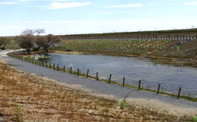
Flood hazard in data scarce regions
We are interested in developing methodologies to evaluate and manage flood hazard in data scarce regions, using freely available satellite datasets at the global scale, as well as free software. We have recently participated in the evaluation of flood hazard in the Licungo Basin (Mozambique) in cooperation with the Spanish Red Cross and the Red Cross from Mozambique, within the project Strengthening national, district and local capacities for response to natural disasters, linking early warning with early action and promoting their scalability (Cea et al. 2022). In Cea et al. (2022) and Cea et al. (2024) these methodologies are applied to the reconstruction of major flood events in Mozambique and to the estimation of the population exposed to flooding. The results obtained show that integrated hydrologic–hydraulic models based on two-dimensional shallow-water equations, as Iber, combined with global rainfall, land use and topography databases, are currently able to reasonably reproduce the extent and peak discharge of extreme flood events in data-scarce basins and are therefore very useful tools for the development of flood management plans in these regions.
Communication of flood risk concepts
Augmented reality models are an accesible way to explain to a non-technical audience the effects of floods and what kind of measures can be taken to diminish their negative effects. They can also be used to explain the communities the positive effects of new flood protection measures. Visualizing a flood in an augmented reality model is much more intuitive than looking at flood maps or technical results. An augmented reality model can be very easily adapted to show people that are not familiar with flood risk concepts, how flooding may affect their home or business, and what measures can be taken to protect them.
We are working on the development of an Augmented Reality Facility to Run Hybrid Physical-Numerical Flood Models. It consists of a sandbox into which a specific topography, as well as other elements as buildings, roads or dikes, can be incorporated. A scanner generates a Digital Terrain Model (DTM) from the sandbox topography, while hydraulic and hydrological parameters can be defined with a simple GUI. These data is used to simulate overland flow in real time, using the hydraulic software Iber+. Quantitative results of flood extension and magnitude are represented directly over the physical topography, yielding a realistic 3D visual effect.
This installation is conceived for both educational and professional uses. A first version of the facility is described in Puertas et al. (2020)
Within the project SATURNO, we developed an Augmented Reality Facility to Run Hybrid Physical-Numerical Flood Models.
Related PhD Thesis
• Desarrollo de un modelo de drenaje dual basado en el acoplamiento de Iber y SWMM. Esteban Sañudo Costoya. Directores: Luis Cea Gómez y Jerónimo Puertas Agudo. 06/11/2024. Sobresaliente Cum Laude.
• Exhancing Hydrological Modeling with Artificial Intelligence. Juan Fernando Farfán Durán. Directores: Luis Cea Gómez. 04/10/2024. Sobresaliente Cum Laude.
• Improving the capabilities of 2D shallow water equation models in hydrological applications. Gonzalo García-Alén Lores. Directores: Luis Cea Gómez y Jerónimo Puertas Agudo. 04/06/2024. Sobresaliente Cum Laude.
• Estudio de inundaciones compuestas en estuarios y tramos de ríos costeros. Aplicación a ríos del Noroeste de España. Javier Sopelana Peralta. Director: Luis Cea Gómez. 07/04/2022. Sobresaliente Cum Laude.
• Cálculo de la transformación lluvia-escorrentía mediante un modelo Saint Venant 2D. Validación mediante datos de campo y laboratorio. Marta Garrido Armas. Directores: Luis Cea/Jerónimo Puertas. 21/11/2017. Sobresaliente Cum Laude.
• Desarrollo de un modelo acoplado 1D/2D para el cálculo de drenaje urbano: modelo numérico y validación experimental. Ignacio Fraga Cadórniga. Directores: Luis Cea/Jerónimo Puertas. 26/06/2015. Sobresaliente Cum Laude. Mención Internacional. Premio Extraordinario.
Related projects
• Enhancing Physically-based Flood Forecasting with Artificial Intelligence (AI4FLOOD). PID2023-148074OB-I00). Funded by Ministerio de Ciencia, Innovación y Universidades. 2024-2027.
• Sistema multiescala híbrido para la predicción en el corto plazo y las proyecciones de cambio climático de la inundación debida a fenómenos compuestos (MyFlood). PLEC2022-009362. Proyectos en Líneas Estratégicas. Funded by Ministerio de Ciencia e Innovación. 2022-2025.
• Digital RAIN, un modelo integral de drenaje urbano (DRAIN). CPP2021-008756. Proyectos de colaboración público-privada. Funded by Ministerio de Ciencia e Innovación. 2022-2025.
• Sistemas de Alerta Temprana frente a inundaciones pluviales en entornos urbanos (SATURNO). PID2020-118368RB-I00. Funded by Ministerio de Ciencia e Innovación. 2021-2024.
• Enhanced Prevention, Warning, Coordination and Emergency Management Tools for Floods at Local Scales (AA-FLOODS). EAPA_45/2018. Interreg Atlantic Area. Funded by European Regional Development Fund. 2019-2023.
• Probabilistic flood prediction with high resolution hydrologic models from radar rainfall estimates (CAPRI). CGL2013-46245-R. Funded by Ministerio de la Economía y Competitividad.